Home > Blog The Log of a Librarian > The Shape of Memory (04)
The Shape of Memory (04)
The Sea That Had to Be Remembered
Marshallese Stick Charts and the Memory of the Sea
This post is part of a series that explores the many ways human societies have stored, transmitted, and transformed memory across time, beyond the narrow histories centered on books and writing. It approaches archives, documents, and memory systems as historically situated technologies shaped by power, ecology, material conditions, and cultural worldviews, while examining forms of transmission often excluded from dominant narratives of literacy and preservation: oral traditions, woven patterns, musical structures, ritual performances, landscapes, bodies, and other living infrastructures of memory. Check all the posts in this section's index.
Beyond the Shoreline
In the Marshall Islands, in the middle of the Pacific Ocean, a navigator could leave an atoll and lose sight of land long before the voyage had truly begun. The destination remained known, named, and present, but for much of the journey it existed as memory before it appeared as horizon.
Navigation therefore depended not only on knowing where islands were, but on recognizing how the sea changed around them: how swells bent, crossed, reflected, and carried the hidden presence of land through motion.
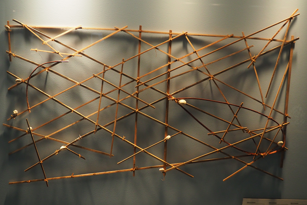
Marshallese stick charts belong to that world. They were not ordinary maps to be carried aboard and consulted at sea, though. Actually, they were models, teaching devices, and memory structures — items through which navigators learned to relate islands, waves, routes, and bodily perception.
Their documentary importance lies in this tension: the object could be preserved, but it could not be fully read as an object alone. They belong to a very particular documentary category. For the chart does not contain the whole knowledge system: it prepares someone to enter it.
Low Islands, Wide Sea
The geography of the Marshall Islands makes that documentary category intelligible. The archipelago consists of low coral atolls and islands spread across a vast area of ocean in two main chains, Ratak and Rālik. These are not high volcanic islands visible from great distances. They rise only slightly above sea level, and, from an approaching canoe, land may remain below the horizon until the vessel is relatively near.
Under such conditions, navigation cannot depend only on visible coastlines. It requires attention to many signs: stars, winds, birds, currents, water color, clouds, floating matter, and especially waves.
Marshallese navigation became famous because of its refined use of wave patterns. Navigators did not simply sail across empty water toward fixed points. They learned to detect how islands disturb the movement of swells. As ocean swells encounter reefs, atolls, and shallow slopes, they may bend, reflect, cross, weaken, or generate distinctive disturbances. These changes can indicate the presence, direction, or distance of land before land itself is visible.
This is the world to which the stick charts belong. The sea is not a blank space between islands. It is an active field of signs. The navigator reads movement, pressure, rhythm, resistance, and disturbance. And the ocean becomes a medium through which land announces itself indirectly.
That is already enough to unsettle the ordinary map analogy. Modern maps often stabilize land and treat water as background. Marshallese wave navigation reverses that habit. Water is not the empty interval between places — it is the primary field of orientation.
Three Forms of Chart
Marshallese stick charts are usually organized in three forms: mattang, meddo, and rebbelib, also written rebbelith in older literature. The categories are useful, though they should not be treated as rigid boxes. Surviving objects vary, interpretations differ, and some charts are difficult to classify cleanly.
The mattang is the most abstract form. It does not represent a specific voyage between named islands. Instead, it models general principles of wave behavior around land. It shows how swells may approach, bend, cross, or interact with an island or group of islands. It is therefore not a map in the usual geographic sense. It is a teaching model. It helps a student learn what kind of relations matter in the sea.
The meddo is more geographically specific. It may represent a smaller group of islands and the wave or current relations among them. It comes closer to what an outside observer might call a chart, but it still does not operate according to the conventions of Western cartography. Its purpose is not to provide a scale drawing of territory, but to preserve navigationally significant relations.
Finally, the rebbelib covers a larger area, sometimes much of one chain or a broader portion of the archipelago. It can gather more extensive island relations into a single framework. But even here the object should not be mistaken for a European-style nautical chart. Its scale, orientation, and internal relations are shaped by navigational knowledge, not by standardized projection.
The value of these distinctions is not mere taxonomic tidiness. They show that the same documentary tradition could operate at different levels of abstraction. The form changed according to the kind of knowledge being organized.
What these objects share is not a single cartographic format, but a way of reducing the sea to teachable relations without pretending that the reduction was complete. The sticks and shells selected certain features from a moving environment and made them available for instruction. Everything else still had to be learned elsewhere: in speech, memory, practice, and the motion of the canoe.
The Chart That Stays on Land
One of the most important things about Marshallese stick charts is that they were not normally carried and consulted during voyages. They were studied before sailing. Their information was memorized. The navigator carried the knowledge in his head, his body, and his trained attention.
In many modern documentary systems, consultation is central. A document waits somewhere until someone retrieves it. A book is opened. A map is unfolded. A file is searched. The document remains outside the body and can be returned to as an external authority.
Marshallese stick charts worked differently. Their documentary power had to be transferred into memory before the voyage. The chart helped form the navigator, but the voyage itself depended on trained perception. At sea, the active interface was not the object. It was the ship, the body, the waves, and the navigator's ability to distinguish meaningful sea patterns from ordinary motion.
The document trained the reader to leave the document behind.
This makes the stick chart difficult for archives and museums. A preserved object can be catalogued, photographed, measured, and displayed. Its materials can be stabilized. Its typology can be described. But its full documentary life cannot be recovered from the lattice alone. The object presupposes a trained interpreter.
Some accounts stress that even a trained person might not fully interpret a chart without help from the maker. This fact reveals the structure of the documentary system itself. Meaning is distributed. It does not sit entirely in the artifact.
A stick chart is therefore not a self-contained document. It is a node in a relation among maker, apprentice, navigator, canoe, ocean, memory, and practice.
Waves, Knots, Roots
Several Marshallese wave concepts help show how rich this system was.
One important pattern concerns the transformation of swells around islands. Incoming swells can bend around atolls and create crossing patterns in the lee of land. Recent collaborative research comparing Marshallese navigation with oceanographic modeling has shown that at least one such pattern, called nit in kōt, can be explained as a lee-wave crossing pattern produced by refraction of the easterly trade wind swell.
Another concept is dilep, often described as a wave path or pattern linking islands. Traditional explanations describe it through crossing or interacting swells. Nodes of intersection are called booj, a word associated with the idea of a knot. A line formed through these intersections may be called okar, "root." Older descriptions compare following the okar toward an island to following a root toward the tree.
The image is exact without being decorative. The navigator does not simply travel from dot to dot. He follows a patterned relation through a field of motion. The island is approached through waves, crossings, knots, roots, and bodily correction. The sea is not a surface over which one moves. It is a structure one learns to read.
But caution is necessary. Not every Marshallese concept translates neatly into Western oceanographic terms. Some wave patterns can be modeled convincingly through refraction, reflection, or crossing wave trains. Others remain difficult to reconcile with available measurements or modern scientific explanation. This does not mean they are false, but that the relation between indigenous navigational knowledge and Western oceanography is not simple.
This is a reminder that the chart belongs to a wider practice of perception, instruction, and movement.
Secrecy, Authority, and Transmission
Marshallese navigation was not general knowledge shared equally by everyone. It was specialized knowledge, held by navigators and transmitted through selected lines of teaching. This matters for understanding the charts. Their partial opacity is not only a modern museum problem. It was already part of their social life.
Knowledge of routes, wave signs, and interpretation carried authority. Navigators were not merely technicians. They held a form of expertise tied to movement, exchange, chiefly power, safety, and survival. The ability to cross between atolls made possible communication, alliances, resource movement, and political connection across the archipelago.
Because of this, navigational knowledge could be guarded. It could be transmitted selectively. It could be protected as family or school knowledge. A chart might preserve information, but not democratize it. It might help teach an apprentice, but not open the system to everyone.
This point helps avoid the modern assumption that documents are naturally instruments of access. Many are not. Some are instruments of restricted transmission. Some stabilize knowledge without making it public. Some preserve authority precisely because only certain people know how to use them.
A stick chart can therefore be visible and restricted at the same time. Its openness is material. Its legibility is social.
Colonial Disruption and the Broken Chain
The history of Marshallese navigation cannot be separated from colonial disruption.
Long-distance canoe voyaging declined sharply during the twentieth century. German and Japanese colonial administrations affected inter-island movement. Modern transport changed the value placed on sailing canoes. War and military occupation interrupted local life. After the Second World War, U.S. nuclear testing in the Marshall Islands produced catastrophic consequences, especially for Bikini, Enewetak, Rongelap, and other affected communities. Displacement, contamination, relocation, and the disruption of everyday life damaged the conditions under which traditional knowledge could continue.
The issue is not simply that objects were collected and placed in museums. The larger problem is that the living ecology of navigation was weakened: canoes, routes, apprenticeship, authority, practice, and the continuity of local life.
Knowledge did not vanish all at once. It persisted in elders, memories, partial practices, models, stories, and revival efforts. But it survived under pressure.
Recent work with Marshallese navigators, including Captain Korent Joel and the organization Waan Aelōñ in Majel, has involved efforts to relearn, reinterpret, and revitalize traditional navigation. These efforts are not simple acts of recovery, as if a complete system had been waiting untouched. They are acts of negotiation. Surviving knowledge has to be taught across changed conditions. Older models have to be compared, remembered, tested, and sometimes reinterpreted. Different navigation schools may preserve different explanations. Indigenous concepts and oceanographic models may agree in some cases and diverge in others.
That tension is part of the archive. The stick chart is not only a document of navigation. It is also a document of the difficulty of documenting navigation after rupture.
Preservation Without Use
Museum preservation gives Marshallese stick charts a second life. Their open frameworks are visually striking. They can be displayed as examples of indigenous science, non-Western cartography, Oceanic navigation, or ethnomathematics. They challenge the old assumption that sophisticated spatial thought requires writing, instruments, paper, or European mapping conventions.
But preservation also creates an illusion. Because the object survives, we may think the knowledge survives in the same way. But it does not.
A stick chart can be intact, but its interpretive world has changed. The shells, the sticks, the knots, all remain. But the routes, training practices, canoe skills, wave sensations, restricted teachings, and lived authority of navigators no longer surround the object as they once did. The preserved artifact is separated from the conditions that made it operational.
Its survival is therefore real, but incomplete. The object remains available for study, display, and interpretation, while the practice that once made it fully usable has to be approached through other traces: testimony, teaching, experiment, revival, and the knowledge still held by Marshallese navigators.
A Document Made for Practice
Marshallese stick charts unsettle the assumption that documents are self-sufficient. They do not preserve navigational knowledge as a closed object that can be separated from the people, practices, and environments that once made it usable. Their open frameworks make selected relations visible, but they do not complete those relations by themselves.
The chart works inside a larger system of instruction, memorization, interpretation, and experience. It is a document not because it contains the whole knowledge of navigation, but because it helps organize the conditions through which that knowledge can be learned and transmitted.
For a history of documents, this distinction is essential. The stick chart is not an unusual book, and it is not simply a non-Western equivalent of a nautical chart. It belongs to another documentary logic: one in which an object supports memory without replacing it, fixes certain relations without making them fully autonomous, and gives form to knowledge that remains dependent on practice.
These objects mark a passage between teaching and use — and between what can be modeled and what must still be recognized through movement.
Bibliography
- Ascher, Marcia. (1995). Models and Maps from the Marshall Islands: A Case in Ethnomathematics. Historia Mathematica, 22 (4), pp. 347-370.
- Davenport, William H. (1960). Marshall Islands Navigational Charts. Imago Mundi, 15, pp. 19-26.
- Genz, Joseph H. (2016). Resolving Ambivalence in Marshallese Navigation: Relearning, Reinterpreting, and Reviving the "Stick Chart" Wave Models. Structure and Dynamics, 9 (1), pp. 8-40.
- Genz, Joseph H.; Aucan, Jérôme; Merrifield, Mark; Finney, Ben; Joel, Korent; and Kelen, Alson. (2009). Wave Navigation in the Marshall Islands: Comparing Indigenous and Western Scientific Knowledge of the Ocean. Oceanography, 22 (2), pp. 234-245.